PCT Map #7 S Oregon

Pacific Crest Trail
Pacific Crest National Scenic Trail
PCT – Hiking Map #7

USDA PCT Map 7

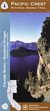
Cascade Mountains in Southern Oregon

USDA PCT Map 7PNW, Pacific Northwest
MAP number 7
Pacific Crest Trail, Southern Oregon, PCT, OR, day hikes, overnight hikes, backpacking trails, outdoor vacations, Oregon recreation, rivers, kayaking, camping, canoeing, swimming, river rafting, hiking, mountain biking, traveling.

USDA PCT Map 7

USDA PCT Map 7

PCT Map Siskiyou Mountains. by NatGeo

The Pacific Crest Trail Map Pack Bundle of Oregon includes 2 Topographic Map Guides that cover the entire PCT as it traverses the incredible terrain of the Beaver State. The maps start at the lowest point of the PCT, Cascade Locks, where it passes over the Columbia River, and continue past the many volcanic cones of the Cascade Range. The Oregon South booklet ends at the border of California in the Siskiyou Mountains.


Oregon is a state in the Pacific Northwest region of the United States. The Columbia River delineates much of Oregon’s northern boundary with Washington, while the Snake River delineates much of its eastern boundary with Idaho. The 42° north parallel delineates the southern boundary with California and Nevada.

Oregon is one of the most geographically diverse states in the U.S., marked by volcanoes, abundant bodies of water, dense evergreen and mixed forests, as well as high deserts and semi-arid shrublands. Mount Hood, a stratovolcano, at 11,249 feet elevation is the state’s highest point. Oregon’s only national park, Crater Lake National Park, comprises the caldera surrounding Crater Lake, the deepest lake in the United States. The state is also home to the single largest organism in the world, Armillaria ostoyae, a fungus that runs beneath 2,200 acres of the Malheur National Forest.

Oregon is 295 miles north to south at longest distance, and 395 miles east to west. With an area of 98,381 square miles, Oregon is slightly larger than the United Kingdom. It is the ninth largest state in the United States. Crater Lake National Park, the state’s only national park, is the site of the deepest lake in the United States at 1,943 feet.

National Geographic Reference Map for PCT


see also –

Columbia River Map
Oregon Hiking Books
Oregon Dunes Map
Rogue River Guide Book

Marin Hiking Maps

Marin Hikes: Bay Area Trail Maps

Marin Hiking Maps

Tom Harrison Maps for Marin County

Marin Hiking Maps

Tom Harrison makes the most topographic trail maps for the San Francisco Bay Area, which include hiking, mountain biking routes as well as trail camps and campgrounds. Printed on waterproof plastic, the durable outdoor maps are known to last decades and are indeed, tear-resistant.

North Marin, Novato Map

Marin Hiking Maps

Tom Harrison Trail Map: Marin Hiking Trails, North Marin County, Novato California Hikes. Rush Creek, Marin Deer Island, Indian Tree, Little Mountain, Verissimo Hills, Stafford Lake County Park, Olompali State Park, Petaluma Marsh, Mount Burdell. Petaluma Hikes Marin. Durable, waterproof plastic map; Folded. Map Scale: 24K; ISBN# 9781877689963

Marin Hiking Maps

Marin Hiking Maps

Central Marin, San Rafael Map

2022 currently unavailable on Amazon

Marin Hiking Maps

Tom Harrison Trail Map: Marin Hiking Trails, Central Marin, San Rafael California Hikes. China Camp State Park, Terra Linda, San Pedro Mountain, Sleepy Hollow, Corte Madera Marsh, Sun Valley Hikes, Fairfax, California, Ross Valley, Greenbrae, Baltimore Canyon Preserve, Blithedale Summit, King Mountain, San Pedro Mountain. Durable, waterproof plastic map; Folded. Map Scale: 24K; ISBN# 9781877689949

Marin Hiking Maps

Southern Marin Hiking Map

Southern Marin County Hiking Map, Marin Redwood Forests, Marin Topo Map. Mill Valley Trails, Fort Baker, Ring Mountain Trails, Horsehill Preserve Marin Headlands, Tiburon Peninsula, Rodeo Valley, Oakwood Valley, Tennessee Valley mountain bike trails, equestrian, paragliding spots, parasail, biking trailheads Marin beaches, backpacking topos, beach waterfalls. Mountain Biking Maps. Tom Harrison; Mill Valley Hiking Maps. Durable, waterproof plastic map; Folded. ISBN# 9781877689901

Marin Hiking Maps

hiking

Marin Hiking Maps

Red Buttes Wilderness Map

Red Buttes Wilderness Map

Red Buttes Map USDA

This map is outta print!
Check Ranger Stations for availability. (see below)

hikers mapRed Buttes Wilderness Map Oregon
Siskiyou National Forest Applegate Ranger District, Rogue River National Forest

OR Topo Maps, Oregon Maps backpacking, hiking, camping, fishing; Illinois Valley Cave Junction, Klamath River California, RedButtes Wilderness Hiking Map, Topo Red Buttes Oregon, Applegate River Topographical Hiking Maps Northern California, Siskiyou NFS, Siskiyou Forest, Whiskey Ridge, at the California Oregon border.

Sierra map

Red Buttes Wilderness is situated in both Oregon and California and includes the crest of the Siskiyou Mountains between the Rogue River and Klamath River drainages. The wilderness is 13 miles long and 6 miles wide, with elevations ranging from 2,800′ in Butte Fork Canyon to 6,740′ at the east summit of the Red Buttes.

The main waterways that flow through Red Buttes Wilderness are all part of the Rogue River watershed, including the Butte Fork and the Middle Fork of the Applegate River, as well as Sucker Creek, a tributary of the Illinois River. The Wilderness contains the headwaters of the Illinois River.

Red Buttes Wilderness takes its name from the dominant peak along the Siskiyou Crest; because of its high iron and magnesium content, the butte’s rock is a reddish-orange color.

The Siskiyou Mountains are part of the larger Klamath Mountains Province of southwestern Oregon and northwestern California, and they include some of the oldest rocks in the region.

The former ocean-bottom sediments that make up most of the Wilderness are several hundred million years old. Over time they were slowly changed by pressure and heat into the complex variety of metamorphic rocks present today: schist, quartzite, gneiss, and several outcrops of white marble. During the last ice age small glaciers sculpted the Siskiyou basins that now contain lakes and meadows.

Red Buttes Wilderness Map

Closest USFS stations:

Happy Camp Ranger Station
Oak Knoll Ranger District
63822 Highway 96,
Happy Camp, CA 96039
530-493-2243

US Forest Service: Star Ranger Station
6941 Upper Applegate Rd,
Jacksonville, OR 97530
541-899-3800

fishing map

see also –

Oregon Dunes Map
Rogue River Float Guide
Rogue River National Forest Map
Columbia River Map
PCT Map #7 Southern Oregon
PCT Map #8 Northern Oregon


California Trail Users Coalition

California Trail Users Coalition

The California Trail Users Coalition is a non-profit corporation designed to be a forum for all trail users (hike, mountain bike, horse, wildlife & vehicle) to discuss related issues, problems and alternative solutions; to assist in the planning, development, maintenance and hosting of trails; and to help enforce the rules of the road; and to develop and maintain programs designed to educate users on proper use of trails and trail etiquette.

Find all CTUC Trail Maps @ jawbone.org
jawbone.org/ohvmap/index.php/maps-guides/ctuc-trail-maps

California Trail Users Coalition

avenza maps Avenza Maps, offers apps and digital maps. Below are all the CTUC maps for California.

CTUC: California Trail Users Coalition Digital Maps
OHV,
SVRA, BLM, 4×4, ATV, UTE, SUV

many desert locations, and some mountains

listed from north to south

CTUC Stanislaus NF & Yosemite OHV Map
CTUC High Sierra OHV Map
CTUC Sierra National Forest OHV Map
CTUC Sierra Bass Lake OHV Map

CYUC Inyo National Forest South
CTUC Inyo National Forest North

CTUC Sequoia NF & Kennedy Meadows OHV Map
CTUC BLM Keysville & Sequoia NF OHV Map

CTUC Jawbone Canyon & Randburg OHV Map
CTUC Panamint Valley OHV Map
CTUC Dumont Dunes OHV Map
CTUC Amboy Mojave OHV Map
CTUC Mojave El Mirage OHV Map

CTUC Needles OHV Map
CTUC Blythe OHV Map

CTUC San Bernardino & Barstow BLM OHV Map
CTUC Angeles Forest OHV Map
CTUC Cleveland & Idyllwild OHV Map

CTUC Palm Springs OHV Map
CTUC Ocotillo Wells OHV Map

CTUC Imperial Sand Dunes Map

dirtbikersrandsburg

Dirt Bikers @ Randsburg Ghost Town, North Mojave, CA

driftwood

tire

solo_driver

Horse Canyon, North Mojave Desert