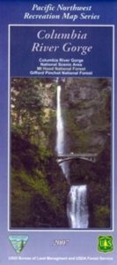
Columbia River Gorge
On the border between Oregon and Washington state, this huge river gorge is a recreation paradise. Fishing, camping, kayaking, wind surfing, hiking and much more.
Columbia River Gorge National Scenic Area
Columbia River Map NFS
Columbia River Camping, Oregon Hikes, Columbia River Gorge Campgrounds
Recreation Map Oregon Washington. Topographic Map. Pacific Northwest Recreation, Outside in Oregon, Columbia River National Scenic Area, Maps, Mount Hood National Forest, Gifford Pinchot National Forest
On the borders of southern Washington state and the north boundary of Oregon lies the Columbia River Gorge, which cuts through the Cascade Mountain Range, and is the deepest, spectacular river canyon on the entire west coast. 80 miles long and 4,000′ deep. Bird watching, boating, camping, fishing, hiking, mountain biking, picnicking, rock climbing, windsurfing, wildflowers. Waterfalls in Oregon. Multnomah Falls is the second highest in the United States.
Map Scale: 1 inch = 1 mile; BLM & USDA. Printed in 2007 on waterproof plastic. This map can also be found at USFS Ranger Stations.
![]()
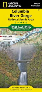
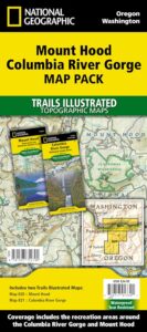
National Geographic has a full color map for this region
Columbia River Gorge NSA
Map #821