Six Rivers Topo Atlas

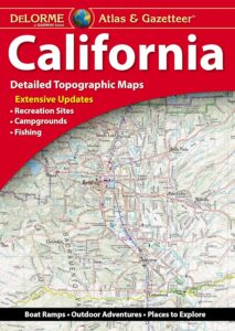
6 Rivers Atlas Topo USDA
Six Rivers National Forest

6 rivers atlas

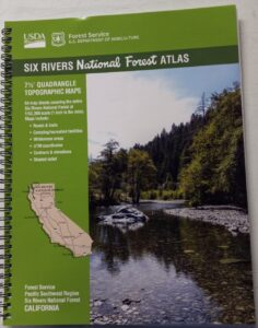
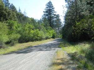
The 6 RIVERS atlas, is a spiral bound book – a collection of all the quads. (7½ minute topographical maps, of all of Six Rivers National Forest, California) This book map has detailed topo lines, mountain peaks, streams, lakes, hiking trails & back roads. Perfect for all kinds of recreational needs. These particular maps are on a per order basis, meaning most have to be special ordered from the ranger – which takes about a week to get them. USDA Forest Service book atlas.

Six Rivers Forest

Six Rivers National Forest QUADS:
from south to north –

  • Four Corners Rock
  • Long Ridge
  • Lake Mountain
  • Swim Ridge
  • Shannon Butte
  • Zenia
  • Alderpoint
  • Smokey Creek
  • Forest Glen
  • Ruth Lake
  • Black Lassic
  • Sporthaven
  • Dinsmore
  • Showers Mountain
  • Blake Mountain
  • Hyampom
  • Hyampom Mountain
  • Sims Mountain
  • Board Camp Mountain
  • Mad River Buttes
  • Ironside Mountain
  • Hennessy Peak
  • Grouse Mountain
  • Maple Creek
  • Denny
  • Salyer
  • Willow Creek
  • Lord-Ellis Summit
  • Trinity Mountain
  • Tish Tang Point
  • Hoopa
  • Salmon Mountain
  • Hopkins Butte
  • Weitchpec
  • Forks of the Salmon
  • Orleans Mountain
  • Orleans
  • Fish Lake
  • Johnsons
  • Medicine Mountain
  • Somes Bar
  • Bark Shanty Gulch
  • Lonesome Ridge
  • Blue Creek Mountain
  • Ah Pah Ridge
  • Ukonom Lake
  • Ukonom Mountain
  • Dillon Ukonom
  • Chimney Rock
  • Summit Valley
  • Klamath Glen
  • Requa
  • Prescott Mountain
  • Ship Mountain
  • Cant Hook Mountain
  • Childs Hill
  • Devils Punchbowl
  • Hurdygurdy Butte
  • Gasquet
  • Hiouchi
  • Broken Rib Mountain
  • Shelly Creek Ridge
  • High Plateau Mountain
  • High Divide

hikers map

camp map

river map
see also –
Six Rivers NF Map
PCT Map Cascades

Los Padres Forest Topo Atlas

Los Padres Atlas
Topographic Map USDA

Los Padres Atlas USDA

Los Padres Forest Atlas

USFS, United States Forest Service – aka National Forests

Ventura, Ojai, Santa Barbara Mountains, Mount Pinos, San Luis Obispo, Big Sur Coast
Mountains: Central Coast California

Los Padres National Forest

Los Padres Forest Atlas

a spiral bound book – a collection of all the quads. (7.5 minute topographical maps, of all of Los Padres National Forest) It includes both Los Padres NORTH (Monterey) & SOUTH (Ojai/Pinos). This book map has detailed topo lines, mountain peaks, streams, lakes, hiking trails & back roads. Perfect for all kinds of recreational needs.

camp maps

Los Padres Forest Atlas

Older version of Los Padres Atlas

Los Padres Forest Atlas

Big Sur Coastal Mountains

Los Padres Forest Atlas

camping & exploring, Los Padres –
links and destinations

Pine Mountain @ Mil Potrero, as seen from top of Mount Pinos, CA

Mt Pinos California

pinos trails

Hiking Trails on Mount Pinos

see also –

Big Sur Maps
Los Padres National Forest Map
Sespe Wilderness Map 

California DeLorme Atlas

DeLorme California

The Delorme brand used to have two separate atlas books for Northern California & Southern California, but they recently figured out how to combine them into one single atlas.
Delorme California

California DeLorme AtlasUniquely versatile DeLorme Atlas & Gazetteer. These topographic atlases cover individual states with the most comprehensive detail available, including back roads, backwater lakes and streams, boat ramps, forests, wetlands, trailheads, campgrounds, public lands, prime hunting and fishing spots, and countless landmarks and points of interest. You’ll also find a wealth of information on everything from family outings to wilderness adventures. The Atlas & Gazetteer is ideal for outdoor recreation, business travel, home or office reference, and countless other uses.

California DeLorme Atlas  California Camping

California DeLorme Atlas

Free Camping on California National Forest Roads

California DeLorme Atlas

see also – 

Benchmark California
National Forest Atlas
State Atlases

Angeles Forest Topo Atlas

Angeles Forest Atlas

Angeles Forest Topo Atlas

Angeles Crest Map / Angeles National Forest

Angeles National Forest

The ANGELES FOREST atlas, is a spiral bound book – a collection of all the quads. (7½ minute topographical maps, of all of Angeles back country) This book map has detailed topo lines, mountain peaks, streams, lakes, hiking trails & back roads. Perfect for all kinds of recreational needs. Published in 2018. ISBN# 9781628114317

Angeles Forest Topo Map / Angeles Forest Camping / Angeles Crest Hiking Trails / Mountain Bike Routes 

Angeles Forest Atlas

Piru Lake, as seen from Whitaker Peak (4148′ elev)

trail map

Angeles National Forest QUADS:National Forest Maps
from south to north –

  • Cucamonga Peak
  • Mount Baldy
  • Glendora
  • Azusa
  • Mount Wilson
  • Pasadena
  • Telegraph Peak
  • Mount San Antonio
  • Crystal Lake
  • Waterman Mountain
  • Chilao Flat
  • Condor Peak
  • Sunland
  • San Fernando
  • Phelan
  • Mescal Creek
  • Valyermo
  • Juniper Hills
  • Pacifico Mountain
  • Acton
  • Agua Dulce
  • Mint Canyon
  • Newhall
  • Val Verde
  • Piru
  • Sleepy Valley
  • Green Valley
  • Warn Springs Mountain
  • Whitaker Peak
  • Cobblestone Mountain
  • Del Sur
  • Lake Hughes
  • Burnt Peak
  • Liebre Mountain
  • Black Mountain
  • Fairmont Butte
  • Neenach School
  • La Liebre Ranch
  • Lebec
  • Tylerhorse Canyon

camp maps

see also –

Angeles National Forest Map
Angeles Map by NatGeo
Angeles Front Country Map
Angeles High Country Map
Angeles Hiking Books
PCT Map #2 Angeles
San Gabriel Mountains Map
Mount Wilson Map
Mount Baldy Map
Cucamonga Wilderness Map 

hikers map