![]()
 California has many State Parks, State Recreation Areas, State Historic Parks, State Vehicle Recreation Areas and also an abundance of ocean front State Beaches. Most of the State Park hiking maps are offered by cartographer Tom Harrison. Plus we link to additional regional maps of interest.
Angel Island State Park
Angel Island & Alcatraz Map
Anza Borrego State Park
Anza Borrego Desert Map (Wilderness Press)
San Diego Backcountry Map (Tom Harrison)
Big Sur Coast State Parks
Big Sur Map
Bodie Ghost Town
& Mining Camp @ Bodie State Historical Park
Bodie Hills Map
Calaveras Big Trees State Park
Merced & Tuolumne River Map (NatGeo)
Castle Crags State Park
Castle Crags Wilderness Map
Lake Tahoe State Parks
Lake Tahoe Basin (USDA)
Lake Tahoe Map (NatGeo)
Tahoe Rim Trail (Tom Harrison)
Malibu Creek State Park, Los Angeles
Mount Tamalpais State Park Maps, Marin
Plumas-Eureka State Park, Northern Sierra
Point Mugu SP Map, Los Angeles

Redwood State Parks NorCal
Redwood Map
Redwood National Park & State Parks
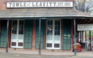
Columbia, California is a State Historic Park
