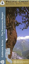
PCT Map #2 Transverse
(Transverse Ranges / San Andreas Fault)
Big Bear to Tehachapi
Pacific Crest Trail National Scenic Trail
PCT – Hiking Map 2
Big Bear Lake to Tehachapi in Southern Sierra Nevada Mountains. Areas include – Big Bear Lake, Holcomb Valley, Lake Arrowhead, Silverwood Lake, Cajon Junction, Cajon Pass, Wrightwood, Big Pines. Jackson Lake, Mount  Lewis, Crystal Lake, Mt. Williamson, Mt. Waterman, Charleton, Mount Pacifico, San Andreas Fault, Chilao Campground, Angeles Crest, Angeles Forest Highway, Los Angeles Forests, Messenger Peak, Lightning Point, Indian Canyon, Agua Dulce, Bouquet Canyon, Elizabeth Lake, Antelope Valley. Large fold out map, durable waterproof paper w/ sturdy cardboard cover. ISBN# 9781593514433


see also –
Big Bear Trail Map
San Bernardino Mountains Map
San Bernardino National Forest Map
San Gorgonio Wilderness Maps
Angeles National Forest Map
Angeles NatGeo Map
Angeles Hiking Maps
Sequoia National Forest Map